")
")


Irriworks at 2010 GisDay
 Irriworks participates in the 2010 GisDay
 The event will take place on Wednesday, Nov. 17 in Palermo:
- In the morning, meeting and poster session at the Sala Magna of the Palazzo Steri
- In the afternoon, workshops on remote sensing and Webmapping at the ARCA Consortium.
Title of the day "GIStales: data, people and tools."
As you know the program IrriPro v.2 uses GIS data from the Google Earth service to perform the survey. In this regard, during the event will be presented a job and a poster made by the company in collaboration with the Faculty of Agriculture, entitled "GIS DATA TO GOOGLE EARTH: RELIABILITY AND USE IN IrriPro". The following is an excerpt of the poster to be presented at the event:
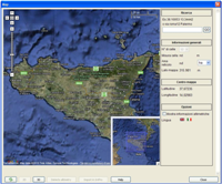 | With an innovative and powerful technology you can make "the relevant horizontal and vertical alignment to you" by Google Earth and get a 3D model of land that you can use in your design. Through this console, you can perform a topographic survey of the land simply by identifying the area to be detected. You can use this feature to: |
- Surf in 2D or 3D, as in Google Earth by entering coordinates or name of the place. - Develop the satellite imagery identified by choosing the precision level of survey from 25 to 2500 points collected from a processing time of up to ten minutes | 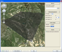 |
 | IrriPro matter the satellite imagery and GIS data (DEM as ASC file) to calculate coordinates and dimensions of each object that will be included in the workspace of the software. The DEM (Digital Elevation Model) product is a raster data model, in the case of 2500 detected points, it consists of a matrix square mesh of 50 rows and 50 columns. The characteristics listed in the plano-altimetric DEM are georeferenced to the UTM-WGS84. |
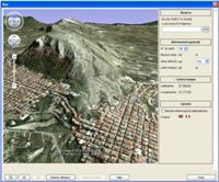
| Knowing the plano-altimetric trend of the land, slopes and elevations will be allocated to the elements (such as pipelines and regulators) according to their position. Throughout the work area, the elevations (listed next to the mouse cursor) were obtained through a SPLINES-type interpolation procedure of DEM data. Intercepting points of equal altitude with lines you get the various contour lines. | 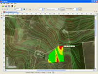 |
CONCLUSIONS OF THE STUDY
The quality of data extracted from GIS service Google Earth is comparable to the same level of a technical mapping on a scale of 1:10,000 and then sufficiently reliable for the design of irrigation systems. In addition, you should not underestimate the great difference of time, resources and equipment to be used for the construction of a detailed survey: For the areas under study, this has required a time of 3 months compared to the few minutes used to extract data through the GE service, whereby it is possible in real time and in the areas where you do not have a traditional cartographic support, to obtain a reliable representation of the difference plot.
Theplan of GisDay 2010 can be consulted here:
http://gisday2010.ticonzero.net/programma
For more information:
http://gisday2010.ticonzero.net/
Visualizzazione ingrandita della mappa
Theplan of GisDay 2010 can be consulted here:
http://gisday2010.ticonzero.net/programma
For more information:
http://gisday2010.ticonzero.net/
Visualizzazione ingrandita della mappa
 IrriPro is available with
 IrriPro has a CAD-style user friendly interface, designed to be used by engineers, agronomists and other technicians. They have all the analisys tool needed to estimate the consequences of any design choice and to represent the trend of any physical parameter.
 The DB is not a list of passive elements, but a way to make the most of the software using existing material on the market.