")
")

What's New
Page 3 of 8
IRRIPRO 3.9
 |  |
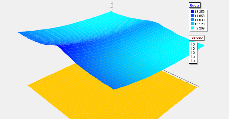
| Thanks to a new interpolation and elevation processing algorithm, Google Maps is now faster in processing, more accurate in creating the 3D model and producing improved image quality. Once the survey is performed, the contour lines will be displayed and, compared to the previous version, will cover the whole area and be placed with 2 meters interdistance. In the figure, the comparison between the survey made with the new version 3.9 and a reference survey in scale 1: 2000. Click on the image to enlarge it. | Version 3.9 includes the new Vyrsa, Toro, Palaplast, InstalPlast and Naandanjain catalogs. Please note that the Freeware version has a very small database and that these catalogs are only available in licensed versions. |
 |  |
| Finally, you can insert new items into the database. Through a window dedicated to each type of element, new joints, new dispensers, new pipes, etc. can be imported. In addition, new types of IrriPro database elements have been introduced, the category of pumps or that of accessories and control units, which have so far been missing. In addition to introducing new products, you can manage and delete items that you just entered. | Improved and faster representation of the 3D graphic of hydraulic quantities. The window will open faster (processing optimized for large installations) and a color gradient image will be displayed. |
For a complete list of advancements and corrections go to History
 IrriPro is available with